Share This Article On Social Media:
Explore Similar Categories:
Republished with permission from the Southside Sentinel.
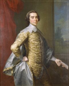
The Richard Henry Lee (RHL) Chapter of the Virginia Society of the Sons of the American Revolution (VASSAR) recently held a meeting at the Indian Creek Yacht & Country Club (ICYCC) near Kilmarnock, featuring Dr. Paul Malone of Urbanna who presented background on John Mitchell (1711-1768), a native of Lancaster County and maker of the famous Mitchell Map, a copy of which is in the Urbanna Museum and Visitors Center.
Malone stressed that Mitchell was much more than a map maker.
Mitchell was born to a family of means with a large estate in the vicinity of Morattico Creek. His father, Robert Mitchell, was a successful planter-merchant. John was sent abroad for higher education. At the age of 18 he had earned a masters degree from Edinburgh University, Scotland. He stayed on to complete two of a three year medical program.
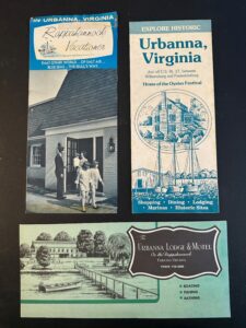
Returning home in 1732 he settled across the Rappahannock River in Urbanna. In 1734 he set up a medical practice in Urbanna. From the beginning it was clear that Dr. Mitchell was interested in research in many fields.
Urbanna was a busy port city in the 1730s and each arriving ship would bring in new diseases. Treatment for these diseases was very primitive. Dr. Mitchell began the practice of autopsies on those who had succumbed to a fever epidemic. He wrote copious notes on each autopsy to include a step-by-step observation on what he observed and what he did. After a time, he sent these notes to the Royal Society in London. It caught the Society’s eye and the notes found their way into medical publications 226 years later in 1967.
Dr. Mitchell had a passion for botany, Malone said. In particular, he was interested in the classification of plants. He would follow the same technique in his study of diseases to experiment in cross fertilization of plants to see what worked and what didn’t. This research was the first attempt to develop an experimental taxonomy of plants that 169 years later was further developed into our current taxonomy of plants.
His fertile mind led him to chemistry experiments. A fertilizer desired in the 1730s was derived from potassium carbonate. Russia and Turkey were the sources of this chemical but would only sell an inferior grade to outsiders. Mitchell conducted experiments until he equaled the best potassium carbonate, and the process he developed is basically what we use even today in fertilizers.
Dr. Mitchell’s agile mind led him to many other challenges of the era. He did work in the field of electricity that led to his meeting Benjamin Franklin and other American scientists.
But Mitchell got fed up with his wife and himself getting sick from the frequent diseases brought to the colonies on ocean-going schooners docking in Urbanna. In 1746, he and his wife sold everything and moved to England. On the way there they were overtaken by a French privateer that took all their property. Arriving in England virtually destitute, he used his knowledge of botany to make money, by telling the nobility what they could grow from plants imported from the colonies.
It was this time in England that Dr. Mitchell made his first map.
The map was made at the request of George Montagu-Dunk, 2nd Earl of Halifax. Not satisfied with the first map, Halifax solicited new maps from the colonies for Mitchell to make a complete map of all the colonies. Halifax, who was president of the Board of Trade and Plantations, wanted a map that would be useful in an expected war with the French in North America.
Dr. Mitchell, with no credentials as a cartographer, went to work to do just that. His product was the map of 1755.
The map was extensively detailed to show, among other things, where one could find a source for salt, meat and lead—items a field army would need. It also showed the sites of friendly and unfriendly Indian tribes and depicted the many roads in the colonies.
The map was very large. It was produced on eight sheets and when laid out it covered a space of 6.5 feet by 4.5 feet. The map was used as the only map source during the Treaty of Paris for defining boundaries of the newly-independent United States. The map was involved in deciding many boundary disputes throughout the 1800s and well into the 1900s. It was used in the dispute between the United States and Canada over Gulf of Maine fisheries in the 1980s.
Dr. Malone then discussed how a copy of the map ended up in a museum in Urbanna. Jessie DeBusk, an official at Bank of Middlesex, wrote a flyer about Dr. Mitchell and the map in preparation for the upcoming Urbanna Tricentennial Celebration in 1980. She heard that a copy of the map might be available in Valley Forge.
A group went there and purchased the map for $7,500. It sat in the bank for the next 20 years. Ultimately it was moved to a storage area where it sat for another 10 years. Getting ready for Founders Day in 2012, a movement was made to have the map restored. A restoration company in Richmond took on the exercise. After the restoration, the map was appraised to have a value of $550,000. The map was carefully returned to Urbanna and now rests in the town museum. Dr. Malone believes this story needs greater publication and that it should be a prime tourist attraction for both Lancaster and Middlesex counties.